Monday, August 8, 2011

Running the Earl Grey Pass

Wow I don't really know where to start with this story. All I can say is; there are "Fun Adventures", and then there are "Tough but rewarding Adventures", and then there are "White Light Adventures"! This was the name of my Adventure racing team that I had through 12 glorious years of adventure racing from 1995-2007. The name was derived from trips that we've all encountered from time to time where the phrases "Shit Happens" or "And then it all fell a part" or in last weekend's case "It was all going so great"...
The Earl Grey Pass is a 63km trail that crosses the Purcell Wilderness Conservancy from Argenta in the West Kootenay's to 20km outside Panorama resort in the East Kootenay's. I knew it wasn't going to be a "quick" 63km, as the Earl Grey Pass Trail is deemed a wilderness trail, so I recruited my best adventure buddy Patrick from the coast who I was confident could handle anything I could throw at him.
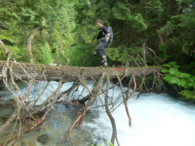
We left the trail head in Argenta at 2:47am figuring that this was going to be a 17-20 hour day and not wanting to do too much in the dark at the tail end of the run. The first 2-3 hours of the run in the dark went by in a flash as we crossed a ragging Hamill Creek by cable car several times. It was actually a little daunting pulling yourself across the river in the pitch black while it raged below you by only a few feet.
The next 2 hours we started to cross many slide paths where the trail became non-existent in the 6-12 foot high walls of Slide Alder, Devils Club and an assortment of other shin ripping vegetation.
Then the trail became non-existent as this years blow down was an exceptional mess...
Couple that with a BC Parks map that I got online where it shows the trail on the wrong side of the river and that it had been rerouted several years back! Although we didn't know that you no longer have to cross the creek anymore, we found creative, but very dangerous ways of crossing it twice that we never had too...Actually 4 times, because we came back the same way :(
To make a long story short, we were forced to make the tough, but smart decision to turn back at 40km into the route because of the incredible amount of blow down. Not knowing how long it would take to reach the pass with no trail and the thought of getting caugh out up high where it was much colder at night made this decision painful, but easy.


One of the many cable car crossings

At 17 hours into the run, although 5 hours of that were spent at a snails pace bushwhacking, we eventually were forced to stop as it got dark as we were both exhausted and knew that finding the trail in the dark was just too much energy. Oh and I failed to mention we were essentially out of food with only a few things left to eat, but were needed for the rest of the run out. I was happy I threw a lighter into my pack as well as an emergency blanket which was graciously supplied by my friend Chris' mother- Thanks Barb!!! ...She actually sent it to me after hearing from her son about an adventure last summer that I froze in the mountains after going too light on a three day trip with only a down jacket, but no sleeping bag...

Although we only shared one bagel between the two of us for dinner, lying by the fire wrapped up in Pine bows in my foil blanket for 5 hours until day break was quite pleasant.


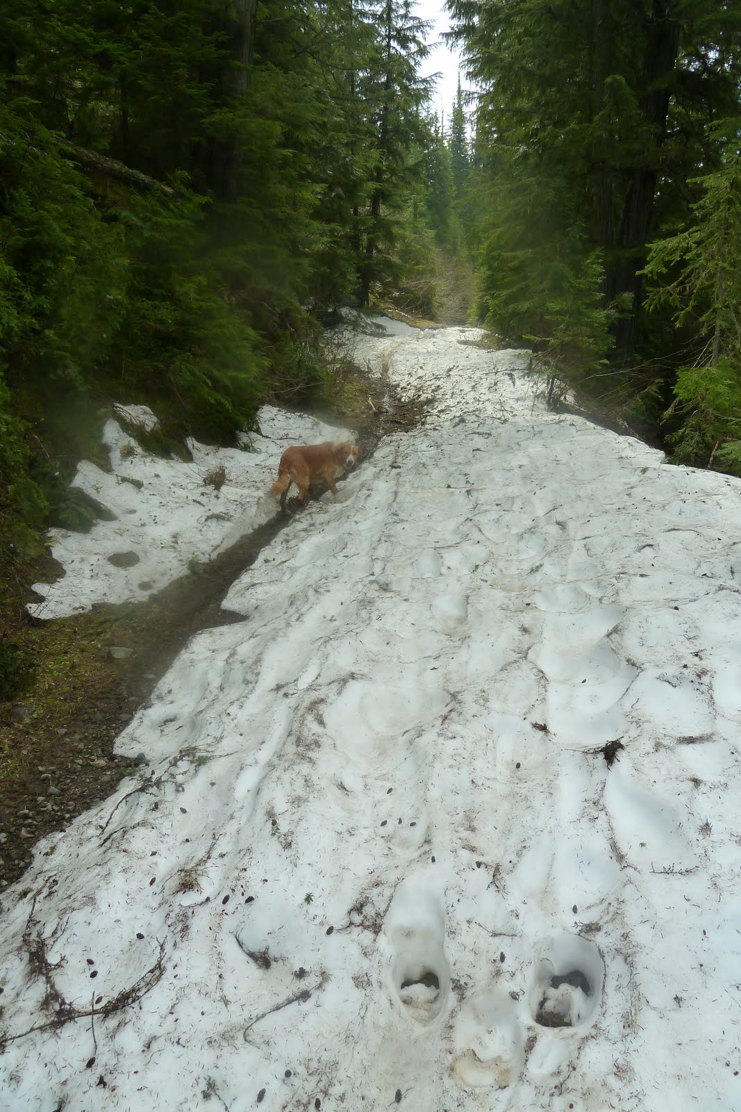
A lot of the trails were great running though

So in a nut shell, We ran 40km in, then 40km out back to the trail head, which is in the middle of nowhere, then another 15km to the HWY to hitch a ride back to Nelson...In total 95km of running and bush whacking.

The Bad:


  1. Not worth doing the trail until they clear it out again


  2. Using the wrong BC Parks map


  3. Must bring a bigger reserve of food next time


  4. Need some shin protectors

The good:


  1. Made amazing time to the back of the valley in 8 1/2 hours and were on a pace to finish in under 15hours


  2. Beautiful remote terrain


  3. Was finally able to put those boy scout survival skills to use


  4. Had a great running buddy who never complained when the shit hit the fan


  5. Looking forward to trying this unfinished business again next year!

Friday, July 29, 2011

Catching up with RTNX race in the Valhalla's

Once in a while you need to blow a day off work, so I thought I'd head off into the Valhalla's to catch up with some of the teams doing the RTNX 7 day adventure race. I figured since I helped design the course, I'd better get out to see how the teams were managing the big traverse through the heart of the Valhalla range from Beatrice lake to Ice Creek Lodge to Gwillim Lakes through Drinnon Pass etc...
Neo and I had a blast crossing creeks and very shortly into the route hitting the snow line.

I was lucky enough to run into the one Kootenay team doing the race- The Kootenay Kaos. For 3 of them it was their first adventure race and being an expedition style race, meaning non stop for 7 days, they had a monumental goal to take on. They had just finished the "Crux" of the race and could smell the finish line 48 hours or so away. In great spirits and great navigation, they seamed to be having an amazing adventure. I am super proud how they are moving through this amazingly challenging course.

Climbing the knife ridge of the Lucifer Pass

Team Kootenay Kaos heading down from Gwillim Lakes through Drinnon Pass.

Hard to believe it's almost August !
Looking down Lucifer Pass north towards Evans lake

A great run/hike that I highly recommend for it's dramatic beauty. Probably the 3rd week of August with the snow gone and the wild flowers out would be the best time...

...Well I hope the weather holds as I am running the Earl Grey Pass this weekend with a friend from Vancouver. I've been looking forward to this run all year so I am now filled with nervous excitement being my first real "adventure" run.

Sunday, July 17, 2011

The Mystery Traverse

As a part of the Raid The North Extreme, a 5-7 day adventure race being held in the Kootenay's this year, I was out checking some of the route that will form part of the race. The race is all back country using map and compass only and is comprised of trekking, Mt. biking, canoeing and ropes. Teams of 4 are given coordinates from point A to B on a topo map and you find your way there, travelling 18-22 hours a day until you complete the 400km-500km course!
Because the course is not reveled until the day before the race, to avoid teams from checking out the route, I can't disclose the location for another week until the race starts. What I can say though, they are up for quite a reward as some of these valley's are remote and pristine, littered with old growth cedars, snow capped peaks, and no logging or mining roads. That said; no reward is handed to you on a silver platter, as they must perservere through long sections of mind f**king bush whacking to eventually be rewarded with mind blowing vista's!!
I lost count how many rivers/creeks we had to cross. This was the only one we didn't have to get wet on.
The cedar forest was amazing although littered with devils Claw
The Alder was relentless, many times down to a crawl on our hands and Knees. There were sections that took us 2 hours just to go one km.
We would break through the Alder onto these little rock islands of mental reprieve for 30 seconds only to put our heads down, literally, and go right back in.
It's amazing how much snow is still up there, although we carried snow shoes, running shoes seamed just fine.
It took my friend Chris and I 12 hours going hard to complete this section through the mountains, which forms only a small portion of the race course.
For you trail runners out there, getting out into the mountains on a big off trail day of hiking, I find does wonders for your mental strength and physical endurance, without being hard on your body. Definitely helps get you ready for those bigger running objectives/races and should be added to your training.

Monday, July 4, 2011

Wildhorse Pass


Running from Nelson to Ymir via the Wildhorse Pass is a relatively gentle 35km run and a wonderful route to give yourself some confidence for off road running. It's less than 3000' of elevation gain/loss along the way- so gentle on the legs too.
We ran parts of the Stanley Loop out to the HWY then cut through the Nordic ski trails to get to the Clearwater parking area. It's amazing how fast the grass grows in this area that we Cross Country skied on only 2 1/2 months ago

From the Clearwater parking lot it is approximately a 12km climb up to the pass- which is just below the snow line in the photo below


We crossed at least 6 icy cold creeks, which I thoroughly enjoyed, as my legs always seamed to respond with renewed vigor.


Below is the turn off at the top of the Pass- not well marked- but just as you start to descend from the saddle into the Wildhorse Valley

Lex and Liz not as used to the "Cold Water Shock Therapy"...don't worry- it will grow on you!


The trail is logging road to the pass and a nice ATV trail on the way down- all at a nice grade

A great 4 hour run to Ymir. You can even finish it off at the Ymir pub for burgers and beer...

Canada Day

Cold wet Kootenay Spring + Big snow year + it's not raining and actually sunny = Skiing Ymir bowl on Canada Day


I even dressed up in my Canada Day summer shirt for the occasion


Not a bad corn snow day for July 1st.......


Sunday, June 19, 2011

Morning Mountain to Rover Creek Traverse

It's been two years now since I started trail running. I've slowly worked my way up with some mileage, so I can start dreaming of venturing out into some incredible terrain that just beckons my call...The 61km Earl Grey Pass is definitely my next big objective for the summer, so I figured I better start cranking up the km's to make sure I feel confident. Not wanting to bother my usual running partners with a big run that I wasn't really sure how far I was going to get, I set out with my faithful companion Neo (I do have to write a future Blog about the privilege of being with your dog in the backcountry)
I started up the Silverking trail to Giveout FSR on another gloomy day that seams to be the norm this season :( - that said; it was a perfect running temperature.
The first hour and a half climb felt so easy and relaxing I just wanted it to go on forever. Only my breathing and Neo's panting broke the wonderful silence.
No fresh steam, but still warm, this bear scat was only 10 minutes old i figured...I'm actually getting good at guessing...Neo is my early warning system though, so I wasn't too concerned.
Up Up and away I could see the highest point on the run in the distance. I knew I'd get to the snow line eventually, but it amazes me how low it still is being June 18th!
I only had to run through the snow for 30 minutes or so, but it felt extra dreary as it started raining on this section.
I was pretty excited to feel the short lived sunshine as i started my big descent toward the 49 creek drainage.


Hit 49 Creek and started my next ascent up the May & Jenny road to and old trail that crosses the valley and connects into Midslope FSR. Lots of wind fall, mud, snow and spring run-off creeks to run through, but loved every minute of it...
I was hoping this was the last valley to cross ( you can see the road where i was heading in the top middle of the picture below)
First view of the valley bottom below. The air was now warmer and it was sunny once again. I knew this last 1'800 foot decent was going to hurt as i was now getting pretty tired.

I think we both feel the same here at the end of the run- pretty damn happy!!...
All told it was just over 5 hours of running the 44km route with 4'000 feet of climbing and 4'800 feet of descending. I think I'd prefer to run it the other way next time. This route would make a great mountain marathon race or just to train for a 50km ultra. It's relatively close to town and even has cell coverage for a lot of it.